


 24/7 Emergency Service
National Weather Service Announces Changes to Severe Thunderstorm Warnings
7/29/2021 (Permalink)
 Always follow the guidance of local authorities when it comes to severe weather!
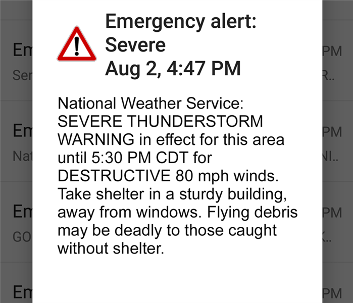
In an effort to better prepare people across the nation for severe weather threats, the National Weather Service will begin adding “damage threat tags” to severe thunderstorm warnings as of August 2nd, 2021. Furthermore, the “destructive” tag distinction will trigger an emergency alert on mobile phones of all within the forecasted damage area. Understanding the different levels of damage threat tags will help you be even better prepared in the case of a severe weather emergency:
- “Destructive” Damage Threat – To fall into this category, a thunderstorm must be forecasted to produce 2.75-inch hail (baseball size) and/or 80 MPH winds. This is the distinction that will automatically trigger an emergency alert to mobile phones within the forecast area.
- “Considerable” Damage Threat – To fall into this category, a thunderstorm must be forecasted to produce 1.75-inch hail (golf ball size) and/or 70 MPH winds.
- “Base” or “Baseline” Thunderstorm – This is the standard severe thunderstorm warning that has previously been in use, and criteria for this category remains unchanged. A thunderstorm capable of producing 1.00-inch hail (quarter size) and/or 58 MPH winds.
These added damage threat tags encourage the public to take action, such as finding shelter and avoiding windows, when a considerable or destructive thunderstorm moves through the area. Added warnings reduce the likelihood of injury to persons within the forecasted area and allow home and business owners within frequently affected areas to consider additional precautions for their properties, such as the installation of storm shutters.
If a baseline, considerable, or destructive thunderstorm causes property damage to your home or business, give the professionals at SERVPRO of North Pensacola a call for help. Serving the communities of Molino, Cottage Hill, Ferry Pass, and surrounding areas, SERVPRO of North Pensacola has the equipment, expertise, and training to handle damages of all sizes. Proud to be of service to Northwest Florida, our team is “Faster to any size disaster!”